

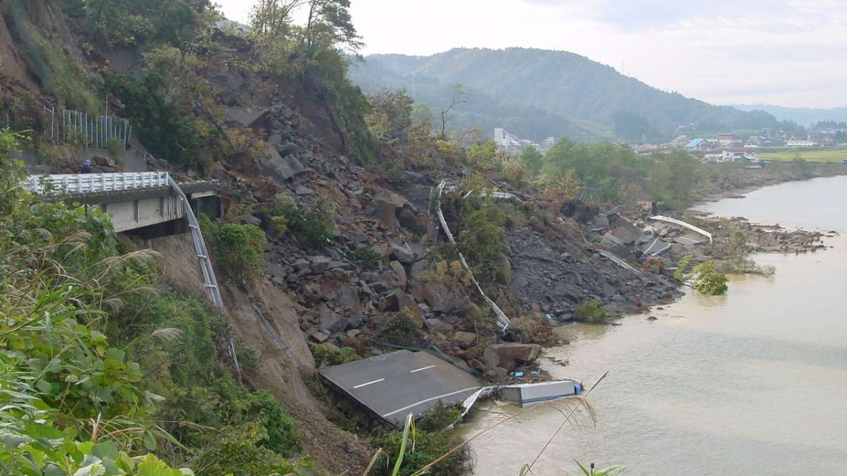
Past experiences with earthquakes have highlighted the crucial role of infrastructures and their structures, both for crisis management as well as for the return to a "normal situation". If they can constitute a safety for users in case of collapse, they also, and above all, play an essential role in the crisis management as well as in the organization of rescue:
-
Routing of emergency assistance (material and human) from neighbouring regions and access to the disaster areas ;
-
Evacuation of victims to hospitals and care centers;
-
Servicing of the local authority’s strategic equipment in the area (crisis headquarters, barracks, vital networks and energy distribution, means of communication...);
-
Recovery of the socio-economic activity in the medium term ;
-
Reconstruction...
The SISMET method has been developed by Cerema to evaluate the vulnerability of a route or road section and the structures located on it (bridges, retaining walls, tunnels and road embankments) to earthquakes.
During the preparation of the crisis management, it helps to identify the structures for which an in-depth diagnosis or interventions are to prioritize.
Prioritize interventions to ensure the safety of the routes
This method consists of defining vulnerability indices established on the basis of sensitivity criteria of the geometric and typological characteristics of each structural element, and to put them in relation with direct and indirect hazards that can threaten the structures in case of earthquake such as ground vibration, block falls, landslides...
A final criterion relating to the strategic importance of the different sections for the passage of emergency vehicles makes it possible to integrate the detour specific crisis management: hospitals, train stations, airports, densely populated areas.
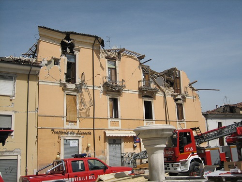
The feedback from past crisis episodes such as Aquila in 2009 in Italy have shown that the damage concerns a limited number of structures, and that structures (bridges and walls) that are old or fragile, the itineraries located in areas of block falls or landslides, in areas of high urban density or on portions of roads such as high embankments that can be destructured ground movements.
This feedback has also shown that that the situation can be considerably improved by by concentrating efforts on the most strategic structures and at a relatively low cost (the cost of reinforcement is generally estimated at about 10% of the reconstruction cost of the structure). Thus, the previously reinforced structures have almost systematically showed a very satisfactory behaviour, showing little or no damage, even when they had been subjected to earthquake levels significantly higher than those taken into account in the calculations.
To define the interventions to be carried out, the associated with the structures and components of the elements of the road is determined by crossing :
-
Direct hazards (soil vibration) and induced hazards (such as block falls, soil liquefaction, falls of buildings on roads) which are determined from the seismic zoning and an evaluation of site effects;
-
Vulnerabilities of the sections and structures (in terms of design, dimensions, foundations...) to determine the capacity of the structure to support the stresses or directly or indirectly induced by an earthquake of a given level;
-
The importance of the stakes in terms of services (social, economic, environmental...) on a scale of low to high importance.
A method applicable to the whole country
This assessment of seismic risk to road infrastructure consists of several phases, corresponding to a progressive narrowing of the of the study perimeter and an associated associated refinement of the level of analysis. The objectives within the framework of the preparation for crisis management, are :
-
Identify routes to be reinforced in priority, through which emergency services can access in case of an earthquake, and find scenarios for the management of these routes. On the global scale of a large area or a large road infrastructure, the approach consists in comparing and prioritizing the itineraries or sections one against the other;
-
Assess whether the structures on the priority routes will be in good condition to allow the circulation of emergency services and, if necessary, identify those requiring a more precise diagnosis, possibly followed by a seismic strengthening study.
This method is based on tools for preliminary evaluation of the seismic risk developed by Cerema, named SISMOA, SISMUR and SISROUTE for the simplified seismic analysis of bridges, walls and current sections (embankments/excavations) of roads, and which allow to realize a first simplified analysis in the framework of the management of road infrastructure assets.
These different tools initially developed for the National Road Network allow to test different scenarios, by locating the epicenter and defining the depth and the magnitude of the earthquake. The SISMET tool is adapted to highly populated areas of urban or peri-urban character. It allows to integrate specific stakes (places that concentrate population, service of local equipment, redundancy of networks...) and the problem of the risk of collapse of buildings on the roads and their structures.
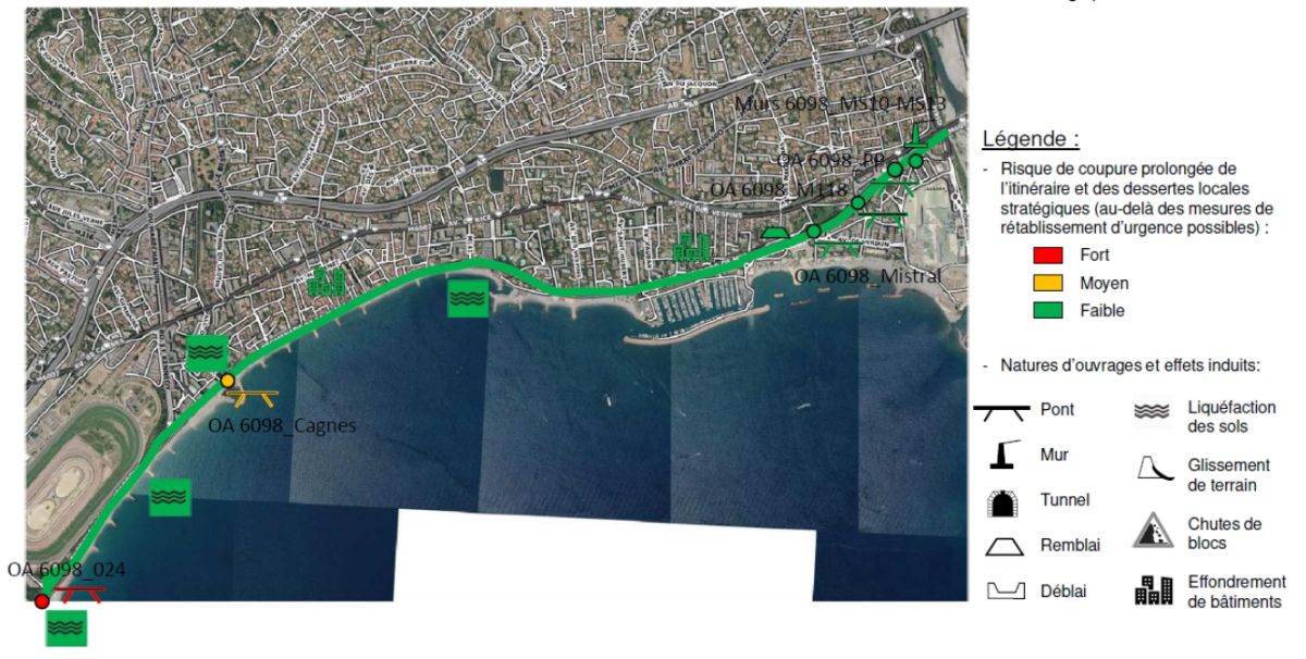
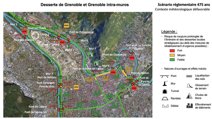
The method was tested initially on a priority axis for serving the Nice area in case of earthquake, integrating a part managed by the Metropolis and another by the Conseil Départemental des Alpes-Maritimes. It was then deployed on the part of the route managed by the Vinci-Escota freeway company, then on other areas in Lourdes and in the Grenoble metropolitan area. Today, it is finalized, it is applicable in all the areas affected by earthquakes and will soon be used in the whole Isère department, in Guadeloupe, and in the Nantes metropolitan area.

The first applications have shown the interest of this approach, particularly in terms of a tool for exchange and decision support between the various stakeholders involved in crisis management: civil security services, prefectures, road infrastructure managers, managers of the main strategic equipment for emergency organization (fire stations, hospitals, energy, communication or water networks, etc.).
They also allowed us to validate the relevance of the approach and its selectivity, allowing to concentrate the means on targeted stakes, in order to reduce the vulnerability of existing transport infrastructures, which are essential for crisis management and the organization of emergency services in the event of an earthquake, in order to ensure the best possible protection of the users and the maintenance of the conditions of these infrastructures and the equipment they serve, according to technical and economic constraints.
In the Alpes-Maritimes, for example, the results of the automated analysis described abovecould be compared with the choice of priority routes previously defined by civil security services (SDIS 06); while in the Hautes-Pyrénées, the application of the SISMET method allowed the DDT 65, within the framework of its Plan de Prévention des Risques to evaluate and compare the level of seismic risk on two possible emergency access routes to the city of Lourdes from Tarbes, in order to know if the rescue services will be able to access the city in case of earthquake.
Within the framework of the Antilles earthquake plan, it is planned from 2022 in conjunction with the DEAL and the Region, to deploy the approach on the Guadeloupe priority routes for crisis management, allowing to test it in strong seismic zone.
The SISMET project was awarded the gold medal in the resilience category at the World Road Association PIARC 2021 Awards during the PIARC France/IDRRIM meetings. In addition to this national distinction, a few months later international recognition at the World Road Congress Calgary 2022 during which the SISMET project was awarded an honorary mention.
Learn more:
In the Nice metropolitan area and the Alpes-Maritimes department, the project, which is now completed, has been the subject of four successive reports corresponding to the different phases of the study.