

Focused on supporting public policies in the areas of planning, regional cohesion and ecological and energy transition, Cerema is at work on issues of global warming and adaptation of regions to its impacts. Overview of ongoing projects and Cerema productions on this subject.
Nature and biodiversity to adapt to climate change
In the city, heat is increased by the phenomenon of heat islands, on which the Cerema teams are working. This is a climatic phenomenon that corresponds to a difference in degrees of temperature between the dense urban environment and its outskirts. It is mostly felt at night because the city stores more heat than the countryside. Greenhouse gases, which are more present in urban areas, continue to trap urban heat. This allows for differences of 1 to 5 °C between the city and the countryside.
Urban heat islands: video explanation
Cooling cities with biodiversity
In a context where temperatures are expected to rise, the question of the resilience of urban ecosystems is a major challenge. The overall safety of the regions requires finding adaptation solutions. Among these solutions, the place of nature in the city is paramount and it must be integrated from the design phase of development projects, and not only at the end of the project.
The European research project Nature 4 Cities, in which Cerema participates, aims to identify and disseminate a range of nature-based solutions for sustainable urban development, via a web platform.
The CoolParks project (Cooling optimisation by parks and urban morphology) will be launched shortly as part of Ademe's MODEVAL-URBA 2019 call for research projects. Cerema will be one of the partners in this project, whose objectives are:
-
To identify the determinants of the coolness creation by urban public parks and its spread to the surrounding urban areas,
-
To develop a decision support tool for local community services to design parks and their built environment to optimise urban cooling, improve thermal comfort and reduce the need for refrigeration in buildings.
Nature thus appears to be an essential lever for cities' resilience to climate change. Ecological engineering manages, preserves and develops ecosystems. Currently, the regions need scientific and technical references, at the crossroads of several disciplines (ecology, urban planning, management of public spaces…), and responses adapted to the local context thanks to the involvement of the region's stakeholders.
Cerema focuses on developing, capitalising and disseminating knowledge of nature-based solutions for land use planning, particularly urban ecosystems. By organising the French Capital of Biodiversity competition, which rewards the actions of the regions in favour of nature and biodiversity, many initiatives are capitalised every year.
Studying heat islands in the regions

With the City of Clermont-Ferrand, for example, Cerema is working on the identification and characterisation of urban heat islands. The City, faced with an urban overheating phenomenon, is deploying a strategy to adapt to climate change. The fight against UHIs (urban heat islands) is part of its energy and ecological transition action plan.
The City called upon Cerema ahead of an upcoming development project in one of the city's main squares. Instruments fitted at seven points of the square and its surroundings provide values (temperature, humidity, pollution…) before and after the developments both in the square itself and on its periphery in a logic of urban pathways employed by users.
In 2018 the heat island phenomenon was objectivised and confirmed around this square, with 3 °C more at night than on the outskirts of the city. Work continues in 2019, in partnership with the Clermont Metropole planning agency, with a detailed diagnosis including: the continuation of fixed measurements supplemented by mobile measurements and also a phase of observation and investigation among users (residents, passers-by) of the public space. The aim is to combine a metrological approach with the identification of the perceptions of people, especially the most vulnerable, to heat (children, the elderly, people at high risk, etc.).
Based on these different observations used to diagnose the phenomenon, guidelines will be proposed to help build the development project by acting on the various parameters (coatings, street furniture, lack of vegetation and water…). A decision-support tool for local authorities will also be developed through this partnership.
For the Greater Nancy Metropolis, Cerema is studying vulnerability to urban heat islands, with an approach based on socio-demographic indicators, the built-up environment and energy consumption, to populate the planning documents of the Metropolis.
Contributing to the development of urban agriculture

Urban agriculture is another avenue for the development of nature in the city. Integrated into the regional strategy and development projects, urban agriculture improves the quality of life of a neighbourhood and helps to combat the heat island phenomenon. Indeed, urban agriculture fulfils several functions: food, social, environmental, and finally economic.
A working group on urban agriculture in EcoQUartiers was set up in 2017 to produce tools and support for local authorities and developers in urban agriculture projects.
Five families of urban agriculture have been identified, which vary according to the stakeholders involved and the business model:
-
Interstitial productive spaces
-
Collective gardens,
-
Urban micro-farms,
-
Specialist urban farms,
-
Suburban vegetable farms.
A guide entitled "Urban Agriculture in the EcoQuartiers" (in French) was published this year, to give references to owners who carry out development projects integrating urban agriculture.
The major urban farming families in video
A Resource Centre on Adapting to Climate Change
![]()
The Resource Centre for the Adaptation of regions to Climate Change will be launched before the end of this year. It will provide reference resources to understand and, above all, to act: guides, tools, etc.
It will be based on the exchange of experiences and actions carried out in the regions by the local authorities and stakeholders concerned. Aimed primarily at local authorities and all those affected by climate change, agricultural world, economic world, development stakeholders, transport stakeholders, businesses, finance, etc., it will enable adaptation solutions to be implemented in the regions.
At the end of 2018, France launched its National Climate Change Adaptation Plan (Plan National d’Adaptation au Changement Climatique - PNACC) for the 2018-2022 period (the Resource Centre for Climate Change Adaptation is one of the main actions of the PNACC entrusted to Cerema). The Regions integrate adaptation to climate change into their Regional Planning, Sustainable Development and Equality Schemes (Schéma régional d'aménagement, de développement durable et d'égalité des territoires - SRADDET), and all local authorities with more than 20,000 inhabitants are also competent to acquire Regional climate-air-energy plans (Plans climat-air-énergie territoriaux - PCAET) which deal with adaptation.
Supported and built by Cerema, in partnership with ONERC (National Observatory for the Effects of Global Warming), ADEME, Meteo-France and other State organisations or operators and in conjunction with communities, it will allow the sharing of experiences and best practices, identify the stakeholders, and provide documentation on several themes related to climate change: city planning, nature-based solutions, transport and mobility infrastructures, buildings, water, soils, biodiversity, natural risks and resilience, health, agriculture, forestry, urban planning, fisheries and aquaculture, tourism and the financial sector.
Regional Observatories of the Effects of Climate Change
In 2001, France set up a National Observatory on the Effects of Climate Change (Observatoire National sur les effets du Changement Climatique - ONERC). It has two main objectives: to collect and disseminate information on the risks associated with global warming and to make recommendations for adaptation measures in order to limit the impacts of climate change.

Regional observatories have also been set up. That of Auvergne Rhône-Alpes (ORECC, Observatoire Régional des effets du changement climatique - Regional Observatory of the Effects of Climate Change) is the result of a collaboration between the Region, DREAL, Ademe and Cerema in order to provide reliable and localised information on the effects of climate change.
Indicators for monitoring the effects of climate change have been defined through a consultation process with users of the observatory, in particular economic stakeholders.
These indicators target human resources and activities relate, for example, to the impacts on water resources, on agricultural or forestry activities, or on snow tourism.
The Pyrenean Climate Change Observatory (Observatoire Pyrénéen du changement climatique - OPCC) has also been opened, with the particularity of being cross-border (France - Spain).
Ensuring summer comfort in buildings

In terms of buildings, one of Cerema's main areas of work is comfort, both in summer and in winter. The environmental regulations in preparation will fundamentally reform the thermal regulations by imposing on all new buildings an absolute limit to summer thermal discomfort and by integrating virtual cooling requirements into the thermal requirements when a non-air-conditioned building does not achieve a minimum level of thermal comfort.
The assessment of summer thermal comfort in buildings is difficult to objectivise because the temperature and hygrometry measurements must be linked to the summer climatic conditions, and the perception of these atmospheres resulting from the interviews with the inhabitants must be linked to the modes of use and thermal management.
To achieve a high level of summer comfort, both good building insulation and control of solar radiation and internal contributions are required: lowering the blinds, closing the shutters, managing devices that emit heat. But this is not enough if the heat build-up during the day is not dissipated at night by good ventilation. Gentle cooling systems can complete these fundamental elements of comfort in temperate climates: heat sink circulating the air under the ground which is cooler, air fans, atomisers for open spaces, etc.
Cerema's work on summer comfort in buildings is conducted with a view to adapting to global warming.
Adapting the mobility of a region to climate change

What are the impacts of climate change on mobility? How can we anticipate these impacts and what are the levers of action to be mobilised in the regions?
A Cerema guide published at the end of 2018 proposes an approach to adapt a region's mobility to the consequences of climate change.
For this, it is important to initiate a reflection on the future of the region, its evolution (in terms of population, economic fabric and land use…) and to integrate local long-term climate forecasts.
The method proposed by Cerema and explained in this guide combines actions to mitigate the region's vulnerability to climate change, and to adapt by anticipating the changes that will have to be made to the region.
Nine effects of climate change on the regions have been identified (e.g.: infrastructure deterioration, impact on river navigation, modification of tourist flows…) along with 7 operational levers to adapt the region.
Transport infrastructure and climate change
An Observatory of drought-affected roads

Roads can be impacted by global warming: the phenomenon of clay shrinkage and swelling (CSS), also called geotechnical drought, causes, through water stress, significant volume displacements of soils, thus affecting the foundations of structures and infrastructures on the surface (individual houses, buildings and road infrastructures).
The impetus of climate change will continue to increase the phenomenon of CSS and will increase the cost of the annual losses generated and borne by the managers of the damaged structures.
In the field of road infrastructures, disorders linked to CSS are frequently characterised by longitudinal cracks with marked subsidence along the edges of the roadway. For this, an "observatory of roads damaged by drought" (observatoire des routes sinistrées par la sécheresse - ORSS) was launched in 2017 by Cerema, in partnership with 5 departmental councils of the Centre-Val de Loire region: Cher (18), Indre ( 36), Indre-et-Loire (37), Loir-et-Cher (41) and Loiret (45).
Since 2009, Cerema's Blois laboratory has invested heavily in the search for innovative techniques through major multi-scale projects, both national and international, to overcome this major problem.
The aim is to experiment with several reinforcement techniques on various sections of departmental roads for 5 years in order to define the most advantageous solutions from a technical and economic point of view for managers. The final promotion of this work will take the form of a national methodological guide on the reinforcement of roads damaged by the CSS phenomenon.
This same phenomenon of clay soil shrinkage and swelling also impacts buildings and their foundations. A new repair method is currently being tested.
Adapting transport infrastructures and networks to climate change
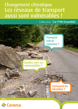
Two free guides intended for elected officials and regional stakeholders involved in the management of infrastructures and transport networks were recently published by Cerema. In 8 pages, these "P'Tits Essentiels" are aimed at those who have to make the decisions, and therefore:
-
Anticipate risks such as the degradation of an infrastructure or the outage of a network due to meteorological hazards,
-
Plan the actions to be taken to improve medium and long-term resilience (repairs, deviations)… and limit expenses.
These two guides remind us that the climate change context must be taken into account in the risk analysis and in the network management strategy. They include a multi-stage approach, from diagnosis, which makes it possible to determine the vulnerabilities, to the definition of the infrastructure and network adaptation strategy: strengthening of certain infrastructures, changes in design or maintenance practices. .
These guides, "Infrastructures routières, s’adapter au changement climatique, une nécessité" (Road infrastructures, adapting to climate change, a necessity) and "Changement climatique - Les réseaux de transport aussi sont vulnérables !" (Climate change - Transport networks are vulnerable too!) can be downloaded from the Cerema online store. Several managers have already taken these steps!
Cerema also supports infrastructure managers in adapting their network to climate change. For example, the Grand Port Maritime de Bordeaux used the risk analysis methodology proposed by Cerema to define a management and adaptation strategy for its infrastructure network.
Taking climate change into account in planning
It is necessary to take climate change into account in the regions, and this involves integrating this issue into planning documents.
For example, the SCoT (regional integrated development plan) or the PLU(i) (inter-communal urban development plan) are used to integrate the heat island phenomenon are. By providing action levers on development, resource conservation, mobility, building and energy, the PLU(i) allows the introduction of regulatory elements to act in favour of "coolness islands"(green space coefficients, presence of water via the green and blue grid, developments in favour of gentle modes). These developments also serve to create a space for dialogue and to introduce these subjects into the community's projects.
At a finer regional scale, "sectoral" planning documents such as the PCAET (specific energy-climate regulatory planning) can mobilise actions in favour of the same levers.
Cerema has designed a series of fact sheets intended for elected officials and local authority technicians, to take into account various issues (energy, air quality…) in the preparation of planning documents.
Cerema also supports certain regions, through partnerships, such as the Saône-et-Loire department, with which a method and a regionalised diagnostic tool have been developed, to take into account the challenges of energy transition and the fight against climate change in town planning documents.
Tools for integrating climate-air-energy issues into town planning initiatives
Cerema has developed applications that allow local authorities to integrate air-energy-climate issues into planning, in order to conduct operational procedures. These tools allow local stakeholders to determine the issues and assess the impact of development scenarios.

Diaclimap (CLImatic DIAgnostic of urban districts for a Planning Assistance Methodology) is now at the end of its development. This decision support tool will identify and characterise urban heat islands at the district level and facilitate the integration of climate diagnosis into urban planning processes.
Clim'Urba serves to integrate climate-air-energy issues into SCoTs and PLU(i)s. The tool defines these challenges, provides support for the development of action levers to ensure their consistency and translation into the town-planning document, and allows the assessment of these levers by analysing the gap between initial ambitions and the final document. It offers a multi-target approach (general public, assessor, decision-maker) allowing flexible adaptation to user needs with different levels of detail. Finally, overview sheets facilitate communication on the process and its results, along with the evaluation of the town planning document.
Clim'urba is a collaborative tool, which opens up dialogue and reflection between elected officials, technicians and experts. Cerema offers tailor-made support for local authorities in these procedures.

GES Urba: This online application was developed by Cerema to assess the impact of development scenarios on the energy consumption and Greenhouse Gas (GHG) emissions of a region , at different scales (SCoT, PLU(i) and PLU). It is used to inform the development of the Planning and Sustainable Development Project (Projet d'Aménagement et de Développement Durable - PADD) and iteratively to test different levers of action in the areas of building (new and rehabilitation), the mobility of people and goods, the development of renewable energies and heating networks as well as land use.
From a diagnosis of the GHG emissions of a region, the application proposes to assess the impact of various levers of action on the energy consumption and GHG emissions of a territory (use and construction of new buildings, rehabilitation, mobility of people and goods, changes in land use, development of renewable energies…) and serves to compare and assess different scenarios by calculating the energy consumed and GHG emissions that could be avoided.
This application, developed with the support of Ademe and the general directorate for planning, housing and nature (direction générale de l'aménagement, du logement et de la nature - DGALN), will be available for testing in the autumn. Do not hesitate to contact us to participate.
Contact for GES Urba tests
A virtual climate summit in November
![]()
From 18 to 28 November 2019, approximately thirty web conferences over 8 days, dedicated to solutions to meet the challenges of climate change, will be organised: the Virtual Climate Summit is aimed at local authorities, businesses and financial stakeholders, to identify the levers allowing rapid action.
Through the testimonies and sharing of experiences of stakeholders and experts, it aims to share best practices and to consider new operational solutions.
Cerema is a partner of this event, organised by the Association of Professionals in Climate, Energy and Environment Consulting (Association des Professionnels en Conseil Climat, Energie et Environnement - APCC). Free and open to all, it is the first of its kind and will allow solutions to be put forward, particularly in terms of financing and implementation of actions.