


Between 2013 and 2017, Cerema worked with Diponegoro University and its Centre for Disaster Mitigation and Coastal Rehabilitation (CoREM) to study the processes of subsidence and marine and continental flooding in Semarang. It was necessary to gain a deeper understanding of this very special area, to identify the natural and human phenomena at play and their interactions, and finally to propose an overall territorial resilience project.
This work was carried out in cooperation with the University of Diponegoro (UNDIP), supported by the French Embassy and then by the Ministries of Foreign Affairs and Research of our two countries. The lessons learned from this cooperation have been capitalised on and disseminated in a book published in French and English.
Today, the Agence Française de Développement is keen to continue Cerema's involvement in this region and has entrusted it with the implementation of the actions previously proposed:
- Creation of a forward-looking observatory for the area,
- drawing up a flood and subsidence risk management strategy in collaboration with local stakeholders.
This is a crucial step for the future of the area.
A town subject to a number of natural hazards, which combine... and are increasing
 This coastal city on the north coast of the island of Java is the capital of the Central Java region. Covering an area of 374 km², it has 17 km of coastline. With a population of 1.7 million, Semarang is undergoing a rapid urban expansion. Semarang is a very dynamic city, with intense economic activity, a large number of facilities and transport infrastructure of national importance.
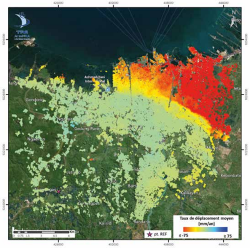
However, the town is heavily affected by a number of natural hazards, in particular the coastal strip. Climate change is exacerbating flooding: rising sea levels are leading to more frequent and more intense marine submersions along the urbanised coastline. Inland flooding is also intensifying, as the ground subsides by a few centimetres to more than 15 cm per year depending on the area.
Together, these phenomena are having a major and lasting impact on the urbanised coastal zone. They are causing major disruption to transport infrastructure and facilities, and severely damaging the living conditions of local residents.
Residents have to fight a constant battle against the flooding of their homes and the sinking of their houses, when they can. For the community, this means raising transport infrastructure, resizing hydraulic structures, raising protective walls, installing and managing pumping systems, etc.
Building risk management tools

The authorities need tools and methods to manage these risks. A large-scale resilience strategy would make it possible to limit the impact of these phenomena as much as possible and to better understand the future of this region. Through this partnership agreement with AFD, a regional observatory on flooding and subsidence and the Local Flood and Subsidence Risk Management Strategy (SLGRIS) will be jointly developed with local stakeholders, in particular the departments of the city of Semarang.
The contribution of everyone's knowledge will ensure that the overall vision is as shared as possible. Finally, scenarios for the development of the area in relation to the various hazards will be proposed to the local authority so that it can decide which one it wants to move towards.
More specifically, this work aims to
- Improve knowledge of the risk of flooding and subsidence in the coastal zone, and monitor its development
- Unite the stakeholders involved in flood and subsidence risk management and in the area around a strategy based on concrete actions,
Within Cerema, a dedicated project team has been set up, drawing on skills in the fields of natural hazards (submersion, flooding, subsidence), territorial resilience, participation and co-construction of projects, and territorial analysis.
The aim will be to bring all these skills together and cross-reference them in order to provide stakeholders with objective information on the current and future overall diagnosis of their area. The aim will then be to co-construct an action strategy. Resilience is seen as both a means and an end. The challenge of bringing this project to a successful conclusion is great, and local stakeholders have high expectations of Cerema.